You are here
Research project
In a recent study conducted by the Chair of Econometrics and Statistics, esp. in the Transport Sector researchers collected and extracted detailed traffic data using a fleet of six synchronized drones. Their work, entitled “MiTra: A Drone-Based Trajectory Data for a Freeway with Ramps Capturing All Traffic States,” was recently published in the renowned Nature Scientific Data Journal.
Prof. Ostap Okhrin, Dr. Martin Treiber, and Ankit Anil Chaudhari from the Chair of Econometrics and Statistics, esp. in the Transport Sector, have collected traffic data using a synchronized drone fleet in a unique research experiment. The project was published in the renowned Nature Scientific Data Journal. The following article provides insights into the research process and highlights how the data set was created and its significance for transportation research, mobility planning and AI development.
Why is traffic so frustrating, and what can we do about it?
We’ve all experienced it: you're in your car, everything’s moving fine, and suddenly, you're crawling. No crash, no construction, no visible reason. Just… traffic. These so-called “phantom jams” are often the result of subtle human behaviors: a late lane change, a hesitant merge, a sudden brake tap. These subtle behaviors ripple backward through traffic, creating so-called "shockwaves" that eventually become full-blown congestion.
To solve traffic problems, we first need to understand how people really drive in real-world conditions— merging, weaving, slowing down, and speeding up. These answers require accurate, high-resolution data.
This is where MiTra (Milan Trajectories) comes in. The drone-based traffic database records detailed vehicle movements in all types of traffic—from free-flowing to complete gridlock—on a major urban highway, the A50, in Milan, Italy. As an open-source application, MiTra provides the data basis for a wide range of application scenarios, such as traffic simulations, testing autonomous driving models, or investigating the connection between lane changes and delays. MiTra is available from OPARA.
What makes MiTra unique?
Unlike past datasets that focused only on free-flow traffic or covered short segments without ramps or used limited camera views, MiTra offers:
• All traffic states from free-flow to congestion—captured naturally at the same location
• Merging and diverging ramps, with realistic driver behavior
• Raw video + stitched trajectories, tracking vehicles across the entire stretch
• Over 124,000 vehicle trajectories, including 52% with lane changes
• 5 vehicle types: cars, buses, trucks, medium vehicles, and motorcycles
• Trajectory data includes speed, acceleration, lane, and IDs of surrounding vehicles (e.g., leader/follower)
Behind the scenes: What it took to record this data
Drones are mobile and flexible, making them perfect for recording areas without fixed infrastructure, such as bridges or towers. However, using drones to study traffic required a lot of planning, coordination and creative problem solving.
Due to new regulations, six drones were used in parallel to capture a 900-meter section of an urban highway. To ensure that the video footage could be seamlessly and precisely stitched together later, the drones had to be very well coordinated in terms of time and space. The limited battery life also had to be taken into account at all times. Since the drones were not allowed to fly directly above the road, the alignment between the drone shots was not always perfect, and occasionally smaller vehicles were obscured behind larger ones such as trucks.
Video behind-the-scenes
The team at the Chair of Econometrics and Statistics, esp. in the Transport Sector, working on the drone footage.
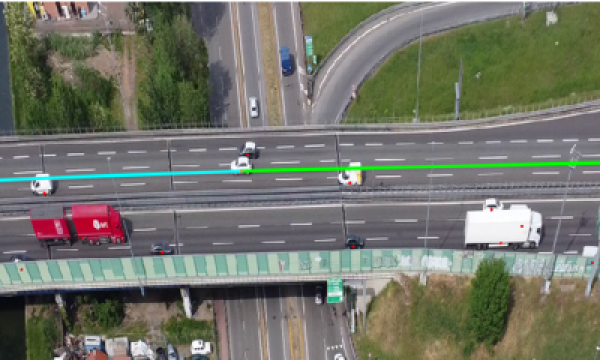
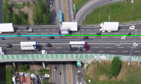
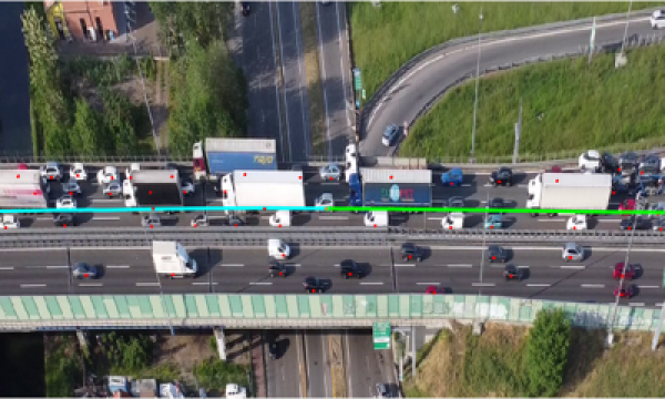
Despite all this, the bird's-eye view provides a unique perspective on traffic flow. The fluctuations recorded naturally over time enable a meaningful analysis of traffic transitions in a uniform environment. Three current snapshots illustrate the diversity of the recorded traffic conditions from our data set:
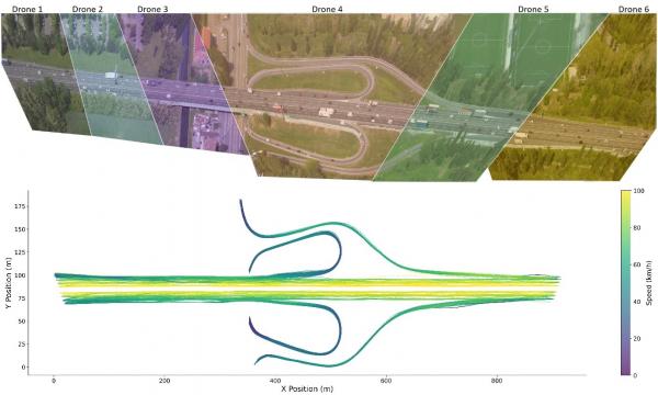
In a final step, the video recordings are stitched together. Vehicle Trajectory data can be extracted from combined/stitched videos.

Video Stitching and Extracted Trajectories. (a) Study section coverage by stitching six drones videos (Image is made by DataFromSky); (b) Extracted Trajectory Data.
By the way: “Mitra” also means “friend” in Sanskrit. Our researchers may have created a dataset that will become a helpful companion for the research community.
Originalautor
Contact
Chair of Econometrics and Statistics, esp. in the Transport Sector
Ankit Anil Chaudhari
Research associate
Tel. +49 351 463-36878
E-Mail ankit_anil.chaudhari@tu-dresden.de
Ultimately, it was a complex operation—but one that paid off with a dataset that we believe will be extremely valuable to the research community. We would like to express our sincere thanks to the DataFromSky team for trajectory extraction and coordination with the drone pilots at Immagini al Volo, who made this complex recording possible.


